The library of the American Revolution Institute recently hosted four graduate students as part of the University of Michigan’s School of Information (UMSI) Alternative Spring Break program. The UMSI students spent a week in Washington, D.C., to work with us on a project, “Mapping the Revolution,” that supports cataloging and digitization of historic and rare maps. Beginning in 2025, a selection of the American Revolution Institute’s maps, charts, views and surveys will be featured in American Revolutionary Geographies Online, a new online resource led by the Leventhal Map and Education Center at the Boston Public Library and the George Washington Presidential Library at Mount Vernon.
To increase exposure and improve the discoverability of the Society of the Cincinnati’s map collection, UMSI students surveyed additional maps, improved catalog records and completed an inventory of cartographical materials which have not yet been digitized. In this post, we are happy to share discoveries made by the University of Michigan team and to highlight their favorite maps to demonstrate how informational professionals can help support the library’s mission to advance scholarship of the American Revolution.
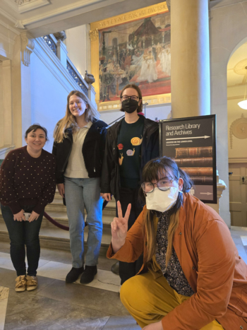
From left to right, UMSI graduate students Sarah Moore, Erin Mettler, Clare Sahijdak and Latitude Brown
“My favorite map is the Carte du Theatre de la Guerre Dans L’Inde ou se trouvent une parue de la Chine, or ‘Map of the Theatre of War in India where part of China is located.’ This map is extremely detailed and shows a series of 18th-century conflicts in India and the East Indies including the Anglo-French War, the Fourth Anglo-Dutch War and the Second Anglo-Mysore War. While not of the United States, this map shows how the American Revolution was a global event and part of a pattern of conflicts and wars that took place around the world. This 1781 map is a single sheet from a series of maps intended to showcase expanding conflicts that then shaped the French Empire. While working to digitize this map, I was able to learn more about the far-reaching effects of the American Revolution and to think more critically about the impacts that seemingly localized conflicts can have on the broader world and political landscape.” – Erin Mettler
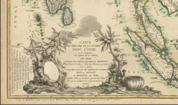
Detail of Carte du Theatre de la Guerre Dans L’Inde ou se trouvent une parue de la Chine, 1781
“My favorite map isVorstellung einiger Gegenden und Plaetze in Nord-America unter Franzoesisch und Englishce Jurisdiction gehoerig, or ‘Presentation of some areas and places in North America under French and English jurisdiction.’ It was printed in Germany in 1756 and includes views of Canadian cities. It’s not just a map of the land, there’s also a ‘plan for the town of Halifax,’ which reflects a once-held vision for the future of the location. I wondered how the past’s future lives up to today’s reality. This map was also hand-colored, which set it apart from other versions. Many of the maps we looked at dated from the 1700s and were over three hundred years old. I currently work with digital and born-digital material, which is much closer to our current day. Over the week at the American Revolution Institute, I learned that maps are another tool held in libraries that help us to imagine hypothetical time travel. Diaries and journals serve as similar primary sources as they document what people did and discussed. However, maps are not only representations of what was, but also what was hoped some places might become. Maps invite viewers to think not just about the geographical transformations but also cultural and political shifts that occurred since their creation. These maps are also pieces of art and pieces of power; they serve as excerpts of how colonialism shaped our world and its future.” – Latitude Brown
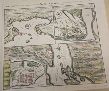
Presentation of some areas and places in North America under French and English jurisdiction, 1756
“My favorite map is the Particular Draughts and Plans of some of the Principal Towns and Harbours belonging to the English, French, and Spaniards in America and West Indies. I enjoyed how it emphasizes the other countries then invested in the Americas. The map depicts thirteen different towns, and it is fascinating to see how these locales differed based on geography and population. Beyond the amazing opportunity to browse rare and historical maps, I researched their accessibility through WorldCat. I counted how many institutions claimed to hold each map and which institutions also had their maps available digitally. I was happy to find that some maps in the Society of the Cincinnati’s collection have not been digitized by any library in the world. This project is a great opportunity for the Society of the Cincinnati to showcase their significant rare map collection and bring in researchers who study events around the American Revolution. Though the collection focuses on the time of the American Revolution, the maps are from all around the world, because the Revolution affected more nations than the United States and England.” – Sarah Moore
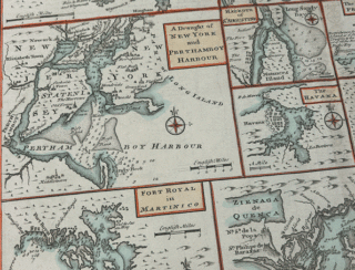
Detail of Particular Draughts and Plans of some of the Principal Towns and Harbours belonging to the English, French, and Spaniards, in America and West Indies, ca. 1747
“One map that I enjoyed working with was called A New Map of the Province of Quebec. This map is from the year 1776 and was pieced together on fabric because the paper has been worn thin from where its previous owner(s) folded it multiple times. I was amazed at how the indexes at the top of the map were stylized to look like additional sheets of paper and how the yellow and teal coastlines were intricately hand colored. This map is truly a work of art. Since I currently work with 20th-century first edition books, I am always fascinated by how the historical objects we study today are things once used in daily life. Working with this map, I was able to have a detailed glimpse into this copy of the map’s physical history, but also how the world was experienced in 1776. Even though we were working to digitize these maps, seeing this map in person at the library has enriched how I understand the period of the American Revolution and how cartographic resources can be described as unique copies in libraries.” – Clare Sahijdak
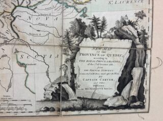
A section of A New Map of the Province of Quebec, 1776
The American Revolution Institute research library and archives houses more than fifty thousand rare books, manuscripts, prints, broadsides, maps and modern reference sources and is one of the most important resources in the world for advanced study on the revolution. The library welcomes researchers to use the collections by appointment and supports scholarship by offering several research fellowships each year to graduate students and advanced scholars. The work supported by students from the University of Michigan’s School of Information Alternative Spring Break on “Mapping the Revolution” will increase and improve digitization of the map collection. Stay tuned for more updates about collections, posts from research fellows, and more.
Click here to learn more about the American Revolution Institute library and collections.